
Schwanden topographic map
Interactive map
Click on the map to display elevation.
About this map
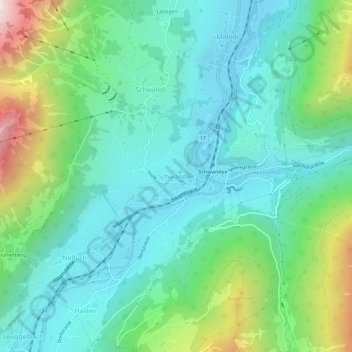
Name: Schwanden topographic map, elevation, terrain.
Location: Schwanden, Glarus Süd, Glarus, 8762, Schweiz (46.97556 9.05136 47.01556 9.09136)
Average elevation: 813 m
Minimum elevation: 498 m
Maximum elevation: 1,744 m
Other topographic maps
Click on a map to view its topography, its elevation and its terrain.
Hätzingen
Schweiz > Glarus > Glarus Süd
Hätzingen, Glarus Süd, Glarus, 8775, Schweiz
Average elevation: 1,035 m
Braunwald
Schweiz > Glarus > Glarus Süd > Braunwald
Braunwald, Glarus Süd, Glarus, 8784, Schweiz
Average elevation: 1,215 m
Muttseehütte
Schweiz > Glarus > Glarus Süd
Muttseehütte, 1, Muttenalp, Glarus Süd, Glarus, 8783, Schweiz
Average elevation: 2,348 m
Tierfed
Schweiz > Glarus > Glarus Süd > Tierfed
Tierfed, Glarus Süd, Glarus, 8783, Schweiz
Average elevation: 1,470 m