
Thank you for supporting this site ❤️
Make a donation
Make a donation
Thesprotia Regional Unit topographic map
Click on the map to display elevation.
Thank you for supporting this site ❤️
Make a donation
Make a donation
Thesprotia Regional Unit
Thesprotia's coastal climate is Mediterranean. Cold winters of a semi-alpine climate dominate the eastern part and higher elevations.
Thank you for supporting this site ❤️
Make a donation
Make a donation
About this map
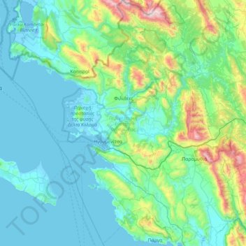
Name: Thesprotia Regional Unit topographic map, elevation, terrain.
Average elevation: 274 m
Minimum elevation: -7 m
Maximum elevation: 1,801 m
Thank you for supporting this site ❤️
Make a donation
Make a donation
Other topographic maps
Click on a map to view its topography, its elevation and its terrain.