
Thank you for supporting this site ❤️
Make a donation
Make a donation
Épernay topographic map
Click on the map to display elevation.
Thank you for supporting this site ❤️
Make a donation
Make a donation
About this map
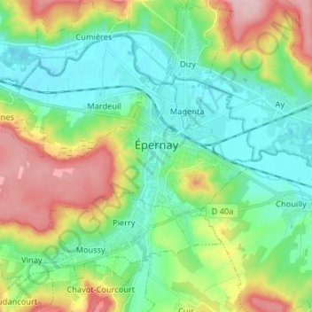
Name: Épernay topographic map, elevation, terrain.
Location: Épernay, Marne, Grand Est, Metropolitan France, 51200, France (49.01798 3.86277 49.06028 3.99365)
Average elevation: 129 m
Minimum elevation: 63 m
Maximum elevation: 269 m
Thank you for supporting this site ❤️
Make a donation
Make a donation
Other topographic maps
Click on a map to view its topography, its elevation and its terrain.
Thank you for supporting this site ❤️
Make a donation
Make a donation
Thank you for supporting this site ❤️
Make a donation
Make a donation