
Thank you for supporting this site ❤️
Make a donation
Make a donation
Palterton topographic map
Click on the map to display elevation.
Thank you for supporting this site ❤️
Make a donation
Make a donation
About this map
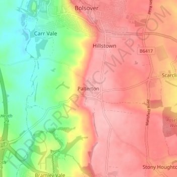
Name: Palterton topographic map, elevation, terrain.
Average elevation: 133 m
Minimum elevation: 63 m
Maximum elevation: 184 m
Thank you for supporting this site ❤️
Make a donation
Make a donation
Other topographic maps
Click on a map to view its topography, its elevation and its terrain.
Thank you for supporting this site ❤️
Make a donation
Make a donation
Glapwell
United Kingdom > England > Derbyshire > Bolsover
Glapwell is a rural village and civil parish on the A617 road in the Bolsover District of north-east Derbyshire, The village is at the top of a steep hill at an elevation of 176m, on the western edge of the Southern Magnesian Limestone] overlooking the valley of the River Doe Lea (formerly known as the…
Average elevation: 156 m
Thank you for supporting this site ❤️
Make a donation
Make a donation
Thank you for supporting this site ❤️
Make a donation
Make a donation