
Thank you for supporting this site ❤️
Make a donation
Make a donation
Pittem topographic map
Click on the map to display elevation.
Thank you for supporting this site ❤️
Make a donation
Make a donation
Pittem
Pittem ligt in Zandlemig Vlaanderen, op een uitloper van het Plateau van Tielt. De hoogte varieert van 18 tot 50 meter. De hoogste punten zijn Pittemberg (44 meter) en nabij Zwarte Gat (50 meter). In het zuiden stroomt de Devebeek zuidwaarts.
Thank you for supporting this site ❤️
Make a donation
Make a donation
About this map
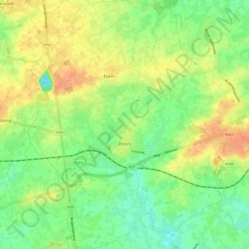
Name: Pittem topographic map, elevation, terrain.
Location: Pittem, Tielt, West-Vlaanderen, Vlaanderen, 8740, België (50.96446 3.22193 51.03715 3.31209)
Average elevation: 30 m
Minimum elevation: 11 m
Maximum elevation: 51 m
Thank you for supporting this site ❤️
Make a donation
Make a donation
Other topographic maps
Click on a map to view its topography, its elevation and its terrain.