
Make a donation
Siek topographic map
Click on the map to display elevation.
Make a donation
About this map
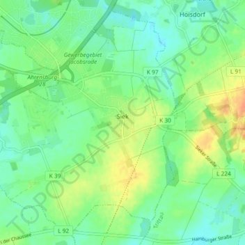
Name: Siek topographic map, elevation, terrain.
Location: Siek, Kreis Stormarn, Schleswig-Holstein, 22962, Deutschland (53.61398 10.24106 53.65368 10.31415)
Average elevation: 58 m
Minimum elevation: 44 m
Maximum elevation: 81 m
Make a donation
Other topographic maps
Click on a map to view its topography, its elevation and its terrain.
Norddeutsches Tiefland
Deutschland > Schleswig-Holstein > Kreis Stormarn > Trittau
Das Euozeanische Klima prägt die Nordseeküste und die vorgelagerten Ostfriesischen Inseln und Nordfriesischen Inseln. Nach Süden schließt sich ein breiter Streifen ozeanisch (= atlantisch) bzw. subozeanisch geprägten Klimas an, der sich von der Ostküste Schleswig-Holsteins bis zu den westlichen…
Average elevation: 36 m
Make a donation
Theodor-Wulff-Höhe
Deutschland > Schleswig-Holstein > Kreis Stormarn > Barsbüttel
Average elevation: 32 m
Make a donation
Make a donation