
Oulan-Oude topographic map
Interactive map
Click on the map to display elevation.
About this map
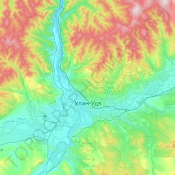
Name: Oulan-Oude topographic map, elevation, terrain.
Average elevation: 720 m
Minimum elevation: 485 m
Maximum elevation: 1,369 m
Other topographic maps
Click on a map to view its topography, its elevation and its terrain.
Oulan-Oude
Russie > Bouriatie > городской округ Улан-Удэ > Oulan-Oude
Oulan-Oude, городской округ Улан-Удэ, Bouriatie, District fédéral extrême-oriental, 670037, Russie
Average elevation: 694 m