
Bellile topographic map
Interactive map
Click on the map to display elevation.
About this map
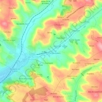
Name: Bellile topographic map, elevation, terrain.
Average elevation: 124 m
Minimum elevation: 60 m
Maximum elevation: 198 m
Other topographic maps
Click on a map to view its topography, its elevation and its terrain.
Saint-Arnaud
France > Nouvelle-Aquitaine > Lot-et-Garonne > Bajamont
Saint-Arnaud, Bajamont, Agen, Lot-et-Garonne, Nouvelle-Aquitaine, France métropolitaine, 47480, France
Average elevation: 142 m