
Make a donation
Mount Lyell topographic map
Click on the map to display elevation.
Make a donation
Mount Lyell
The most common approach to Mount Lyell is from Tuolumne Meadows on a highly traveled section of the John Muir Trail. The round trip is approximately 25 miles (40 km) and involves 4,500 feet (1,370 m) of elevation gain when starting from the Tuolumne Wilderness Office. The hike is easy from Tuolumne Meadows, following the Tuolumne River to the head of the Lyell Canyon, and becomes moderate as it approaches Donohue Pass. Before reaching Donahue Pass, the route leaves the trail and heads south towards Mount Lyell.
Make a donation
About this map
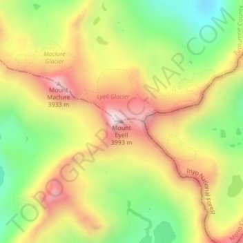
Name: Mount Lyell topographic map, elevation, terrain.
Location: Mount Lyell, Tuolumne County, California, United States (37.73937 -119.27166 37.73947 -119.27156)
Average elevation: 3,626 m
Minimum elevation: 3,283 m
Maximum elevation: 3,975 m
Make a donation
Other topographic maps
Click on a map to view its topography, its elevation and its terrain.
Sonora
United States > California > Tuolumne County
Sonora is located at 37°59′04″N 120°22′54″W / 37.984361°N 120.381767°W / 37.984361; -120.381767, around the intersection of California State Highways 49 and 108 The altitude is 1,825 feet (556 m). According to the United States Census Bureau, the city has a total area of 3.1 square miles…
Average elevation: 615 m
Twain Harte
United States > California > Tuolumne County
Twain Harte is situated in Tuolumne County along Highway 108 at an elevation of 3,640 feet (1,110 m).
Average elevation: 1,123 m
Make a donation
Make a donation
Make a donation
Tuolumne Meadows
United States > California > Tuolumne County > Tuolumne Meadows
Average elevation: 2,668 m
Make a donation
Sonora
United States > California > Tuolumne County
Sonora is located at 37°59′04″N 120°22′54″W / 37.984361°N 120.381767°W / 37.984361; -120.381767, around the intersection of California State Highways 49 and 108 The altitude is 1,825 feet (556 m). According to the United States Census Bureau, the city has a total area of 3.1 square miles…
Average elevation: 615 m
Columbia
United States > California > Tuolumne County
Columbia is located along State Route 49 just north of Sonora, at an altitude of 2,139 feet (652 m).
Average elevation: 672 m
Make a donation