
Thank you for supporting this site ❤️
Make a donation
Make a donation
Green Lane Reservoir topographic map
Click on the map to display elevation.
Thank you for supporting this site ❤️
Make a donation
Make a donation
About this map
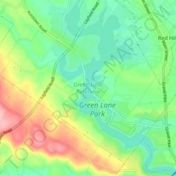
Name: Green Lane Reservoir topographic map, elevation, terrain.
Average elevation: 115 m
Minimum elevation: 68 m
Maximum elevation: 201 m
Thank you for supporting this site ❤️
Make a donation
Make a donation
Other topographic maps
Click on a map to view its topography, its elevation and its terrain.
Palm
United States > Pennsylvania > Montgomery County > Upper Hanover Township > Palm
Average elevation: 131 m