
Cape Solander topographic map
Click on the map to display elevation.
About this map
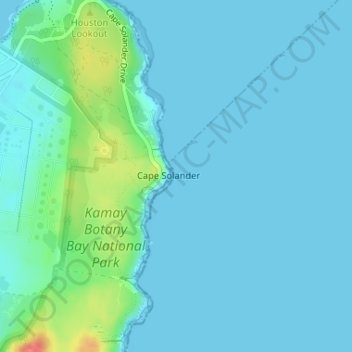
Name: Cape Solander topographic map, elevation, terrain.
Location: Cape Solander, New South Wales, 2231, Australia (-34.01670 151.23240 -34.01660 151.23250)
Average elevation: 9 m
Minimum elevation: 0 m
Maximum elevation: 55 m
Other topographic maps
Click on a map to view its topography, its elevation and its terrain.
Hazelbrook
Australia > New South Wales > Sydney
Hazelbrook is a town in New South Wales, Australia (Elevation: 675 metres) It is located 91 kilometres west of Sydney and 16 kilometres east of Katoomba in the Blue Mountains on the Great Western Highway.
Average elevation: 610 m
Blackheath
Blackheath (postcode: 2785) is an Australian town located near the highest point of the Blue Mountains, between Katoomba and Mount Victoria in New South Wales. The town's altitude is about 1,065 metres (3,494 ft) AHD and it is located about 120 kilometres (75 mi) west north-west of Sydney, 11 kilometres…
Average elevation: 914 m