
Thank you for supporting this site ❤️
Make a donation
Make a donation
Lann Vihan topographic map
Click on the map to display elevation.
Thank you for supporting this site ❤️
Make a donation
Make a donation
About this map
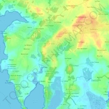
Name: Lann Vihan topographic map, elevation, terrain.
Average elevation: 15 m
Minimum elevation: -2 m
Maximum elevation: 44 m
Thank you for supporting this site ❤️
Make a donation
Make a donation
Other topographic maps
Click on a map to view its topography, its elevation and its terrain.
Étang du Moulin de Baden
France > Bretagne > Morbihan > Baden > Moulin de Baden
Average elevation: 10 m