
Thank you for supporting this site ❤️
Make a donation
Make a donation
Ronquières topographic map
Click on the map to display elevation.
Thank you for supporting this site ❤️
Make a donation
Make a donation
About this map
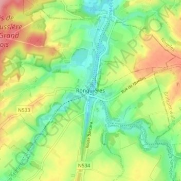
Name: Ronquières topographic map, elevation, terrain.
Average elevation: 93 m
Minimum elevation: 47 m
Maximum elevation: 155 m
Thank you for supporting this site ❤️
Make a donation
Make a donation
Other topographic maps
Click on a map to view its topography, its elevation and its terrain.
Ronquières
België > Henegouwen > Zinnik > 's-Gravenbrakel
Ronquières ligt aan het Kanaal-Brussel-Charleroi dat in noordelijke richting werd aangelegd in het dal van de Sennette. Het historisch deel van het kanaal, een bochtig tracé met vele sluizen, werd aangelegd in het dal van de Samme die hier vanuit het zuidoosten stroomt en te Ronquières voorheen in de…
Average elevation: 96 m