
מועצה אזורית גליל תחתון topographic map
Interactive map
Click on the map to display elevation.
About this map
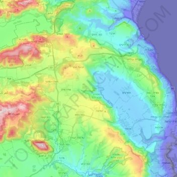
Name: מועצה אזורית גליל תחתון topographic map, elevation, terrain.
Location: מועצה אזורית גליל תחתון, נפת כנרת, מחוז הצפון, 1529500, 以色列 (32.65154 35.31318 32.84919 35.53372)
Average elevation: 110 m
Minimum elevation: -235 m
Maximum elevation: 565 m
Other topographic maps
Click on a map to view its topography, its elevation and its terrain.
戈兰高地
以色列 > מחוז הצפון > מועצה אזורית גולן
戈兰高地, מועצה אזורית גולן, נפת רמת הגולן, מחוז הצפון, 以色列
Average elevation: 533 m