
Make a donation
Campo Mourão topographic map
Click on the map to display elevation.
Make a donation
Campo Mourão
The Township belongs to the Paraná Basin, including the important river Rio Mourão, which crosses the city from south to north. The flow of the river, coupled with the topography of its valley, offers the greatest potential hydrodynamic city, explored with the construction of the Plant Mourão. Other major rivers: Rio Km 119 and Rio do Campo.
Make a donation
About this map
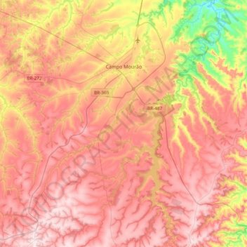
Name: Campo Mourão topographic map, elevation, terrain.
Average elevation: 612 m
Minimum elevation: 355 m
Maximum elevation: 775 m
Make a donation
Other topographic maps
Click on a map to view its topography, its elevation and its terrain.
Curitiba
Brazil > Paraná > Região Metropolitana de Curitiba
The city covers 432.17 km2 (166.86 sq mi) on the First Plateau of Paraná. Curitiba has a topography of smooth, rounded hills, giving it a relatively regular shape. The city has an average altitude of 934.6 m (3,066 ft) above sea level. The highest point is to the north at 1,021 m (3,350 ft), and with lower…
Average elevation: 931 m
Make a donation
Bosque Gutierrez
Brazil > Paraná > Região Metropolitana de Curitiba > Curitiba
Average elevation: 940 m
Itaipu Dam
Brazil > Paraná > Foz do Iguaçu
325 metres (1,066 ft), entire dam including the 100 metres (330 ft) high Power Line 4 Pylons atop the Barrage 260 metres (850 ft), dam + the foundation inside water until the river floor 247 metres (810 ft), 196 metres (643 ft) high of roof reinforcement concrete dam + Cranes atop the Barrage 225 metres (738…
Average elevation: 192 m
Make a donation
Curitiba
Brazil > Paraná > Região Metropolitana de Curitiba
The city covers 432.17 km2 (166.86 sq mi) on the First Plateau of Paraná. Curitiba has a topography of smooth, rounded hills, giving it a relatively regular shape. The city has an average altitude of 934.6 m (3,066 ft) above sea level. The highest point is to the north at 1,021 m (3,350 ft), and with lower…
Average elevation: 931 m
Make a donation
Southern carcara
Brazil > Paraná > Região Metropolitana de Curitiba > Curitiba
Average elevation: 879 m
Curitiba
Brazil > Paraná > Região Metropolitana de Curitiba
The city covers 432.17 km2 (166.86 sq mi) on the First Plateau of Paraná. Curitiba has a topography of smooth, rounded hills, giving it a relatively regular shape. The city has an average altitude of 934.6 m (3,066 ft) above sea level. The highest point is to the north at 1,021 m (3,350 ft), and with lower…
Average elevation: 931 m
Make a donation
Make a donation
Tijucas do Sul
Brazil > Paraná > Região Metropolitana de Curitiba > Tijucas do Sul > Tijucas do Sul
Average elevation: 913 m
Make a donation