
Thank you for supporting this site ❤️
Make a donation
Make a donation
Honey Island topographic map
Click on the map to display elevation.
Thank you for supporting this site ❤️
Make a donation
Make a donation
About this map
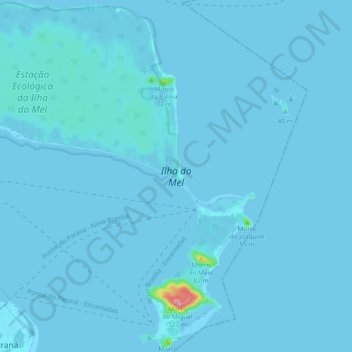
Name: Honey Island topographic map, elevation, terrain.
Location: Honey Island, Paranaguá, Paraná, South Region, Brazil (-25.57628 -48.38244 -25.49260 -48.28955)
Average elevation: 3 m
Minimum elevation: -2 m
Maximum elevation: 129 m
Thank you for supporting this site ❤️
Make a donation
Make a donation
Other topographic maps
Click on a map to view its topography, its elevation and its terrain.