
Thank you for supporting this site ❤️
Make a donation
Make a donation
Totoras topographic map
Click on the map to display elevation.
Thank you for supporting this site ❤️
Make a donation
Make a donation
About this map
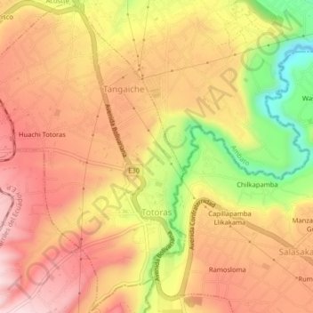
Name: Totoras topographic map, elevation, terrain.
Location: Totoras, Ambato, Tungurahua, Ecuador (-1.32846 -78.63212 -1.28901 -78.59208)
Average elevation: 2,692 m
Minimum elevation: 2,489 m
Maximum elevation: 2,820 m
Thank you for supporting this site ❤️
Make a donation
Make a donation
Other topographic maps
Click on a map to view its topography, its elevation and its terrain.
Thank you for supporting this site ❤️
Make a donation
Make a donation
Thank you for supporting this site ❤️
Make a donation
Make a donation
Thank you for supporting this site ❤️
Make a donation
Make a donation
Thank you for supporting this site ❤️
Make a donation
Make a donation
Thank you for supporting this site ❤️
Make a donation
Make a donation
Calhuasig Chico
Ecuador > Tungurahua > Ambato > Quisapincha > Illagua Chico
Average elevation: 3,336 m
Calhuasig Grande
Ecuador > Tungurahua > Ambato > Quisapincha > Illagua Chico
Average elevation: 3,297 m
Thank you for supporting this site ❤️
Make a donation
Make a donation
Thank you for supporting this site ❤️
Make a donation
Make a donation
Thank you for supporting this site ❤️
Make a donation
Make a donation
Thank you for supporting this site ❤️
Make a donation
Make a donation
Thank you for supporting this site ❤️
Make a donation
Make a donation
Thank you for supporting this site ❤️
Make a donation
Make a donation