
Miles City topographic map
Interactive map
Click on the map to display elevation.
About this map
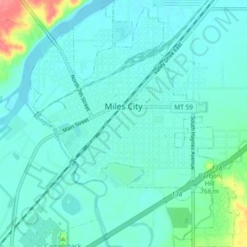
Name: Miles City topographic map, elevation, terrain.
Location: Miles City, Custer County, Montana, United States (46.38294 -105.86553 46.42780 -105.81047)
Average elevation: 724 m
Minimum elevation: 711 m
Maximum elevation: 794 m
Other topographic maps
Click on a map to view its topography, its elevation and its terrain.
Westwood Estates
United States > Montana > Custer County > Miles City
Westwood Estates, Miles City, Custer County, Montana, 59301, United States
Average elevation: 724 m
Carbon Hill Trailer Court
United States > Montana > Custer County > Miles City
Carbon Hill Trailer Court, Miles City, Custer County, Montana, 59301, United States
Average elevation: 732 m
Cook Lake
United States > Montana > Custer County > Miles City > Smiths Trailer Court
Cook Lake, Smiths Trailer Court, Miles City, Custer County, Montana, United States
Average elevation: 721 m
Yellowstone River
United States > Montana > Custer County
Yellowstone River, Custer County, Montana, 59301, United States
Average elevation: 720 m