
La Balanderie topographic map
Interactive map
Click on the map to display elevation.
About this map
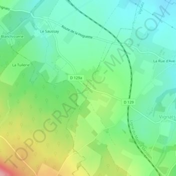
Name: La Balanderie topographic map, elevation, terrain.
Average elevation: 142 m
Minimum elevation: 99 m
Maximum elevation: 231 m
Other topographic maps
Click on a map to view its topography, its elevation and its terrain.
Pertheville-Ners
France > Normandie > Pertheville-Ners
Pertheville-Ners, Caen, Calvados, Normandie, France métropolitaine, 14700, France
Average elevation: 107 m