
Thank you for supporting this site ❤️
Make a donation
Make a donation
Corfu topographic map
Click on the map to display elevation.
Thank you for supporting this site ❤️
Make a donation
Make a donation
Corfu
Two high and well-defined ranges divide the island into three districts, of which the northern is mountainous, the central undulating, and the southern low-lying. The more important of the two ranges, that of Pantokrator (Παντοκράτωρ – the Almighty) stretches east and west from Cape Falacro to Cape Psaromita, and attains its greatest elevation in the summit of the same name.
Thank you for supporting this site ❤️
Make a donation
Make a donation
About this map
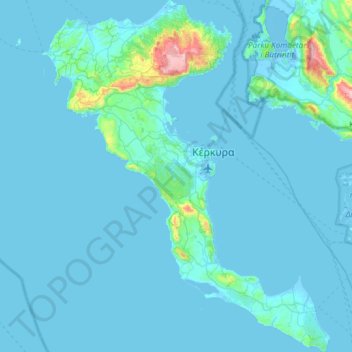
Name: Corfu topographic map, elevation, terrain.
Average elevation: 41 m
Minimum elevation: -7 m
Maximum elevation: 888 m
Thank you for supporting this site ❤️
Make a donation
Make a donation