
Jefferson County topographic map
Interactive map
Click on the map to display elevation.
About this map
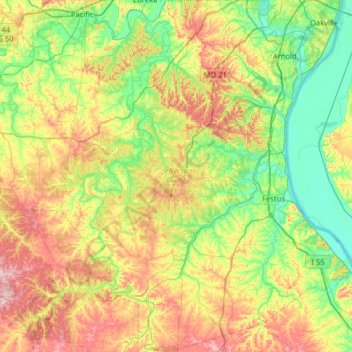
Name: Jefferson County topographic map, elevation, terrain.
Location: Jefferson County, Missouri, United States (38.00345 -90.78040 38.50177 -90.24935)
Average elevation: 195 m
Minimum elevation: 109 m
Maximum elevation: 350 m
Other topographic maps
Click on a map to view its topography, its elevation and its terrain.
Kansas City
United States > Missouri > Jackson County
Kansas City, Jackson County, Missouri, United States
Average elevation: 277 m
Joplin
United States > Missouri > Jasper County
Joplin, Jasper County, Missouri, United States
Average elevation: 303 m
Saint Louis County
Saint Louis County, Missouri, United States
Average elevation: 166 m
Branson
United States > Missouri > Taney County
Branson, Taney County, Missouri, United States
Average elevation: 275 m
Jefferson City
United States > Missouri > Cole County
Jefferson City, Cole County, Missouri, United States
Average elevation: 203 m
Columbia
United States > Missouri > Boone County
Columbia, Columbia Township, Boone County, Missouri, United States
Average elevation: 222 m
Saint Joseph
United States > Missouri > Buchanan County
Saint Joseph, Buchanan County, Missouri, United States
Average elevation: 277 m
Rolla
United States > Missouri > Phelps County
Rolla, Phelps County, Missouri, United States
Average elevation: 310 m
Springfield
United States > Missouri > Greene County
Springfield, Greene County, Missouri, United States
Average elevation: 389 m
Lake Of The Ozarks
United States > Missouri > Camden County > Osage Beach
Lake Of The Ozarks, Osage Beach, Camden County, Missouri, 65079, United States
Average elevation: 265 m
Saint Charles County
Saint Charles County, Missouri, United States
Average elevation: 174 m
Frontenac
United States > Missouri > Saint Louis County
Frontenac, Saint Louis County, Missouri, United States
Average elevation: 179 m
Cape Girardeau
United States > Missouri > Cape Girardeau County
Cape Girardeau, Cape Girardeau County, Missouri, United States
Average elevation: 121 m
Lake Ozark
United States > Missouri > Miller County
Lake Ozark, Miller County, Missouri, United States
Average elevation: 213 m
Independence
United States > Missouri > Jackson County
Independence, Jackson County, Missouri, United States
Average elevation: 261 m
Jackson County
Jackson County, Missouri, United States
Average elevation: 268 m
Osage Hills
United States > Missouri > Saint Louis County > Kirkwood
Osage Hills, Kirkwood, Saint Louis County, Missouri, 63029, United States
Average elevation: 158 m
Poplar Bluff
United States > Missouri > Butler County
Poplar Bluff, Butler County, Missouri, 63901, United States
Average elevation: 112 m
Lynchburg
United States > Missouri > Laclede County
Lynchburg, Laclede County, Missouri, 65543, United States
Average elevation: 400 m
Lincoln County
Lincoln County, Missouri, United States
Average elevation: 189 m
Creve Coeur Lake
United States > Missouri > Saint Louis County > Maryland Heights
Creve Coeur Lake, Maryland Heights, Saint Louis County, Missouri, United States
Average elevation: 150 m
Englewood
United States > Missouri > Jackson County > Independence
Englewood, Independence, Jackson County, Missouri, 64052, United States
Average elevation: 271 m
Clearwater
United States > Missouri > Sainte Genevieve County
Clearwater, Sainte Genevieve County, Missouri, United States
Average elevation: 195 m
Howell
United States > Missouri > Saint Charles County > Harvester
Howell, Harvester, Saint Charles County, Missouri, 63304, United States
Average elevation: 162 m
Des Arc
United States > Missouri > Iron County
Des Arc, Iron County, Missouri, United States
Average elevation: 186 m
Hogan
United States > Missouri > Iron County
Hogan, Iron County, Missouri, United States
Average elevation: 345 m
Belleview
United States > Missouri > Iron County
Belleview, Iron County, Missouri, United States
Average elevation: 328 m
Laclede County
Laclede County, Missouri, United States
Average elevation: 342 m
Enough
United States > Missouri > Iron County
Enough, Iron County, Missouri, United States
Average elevation: 374 m
Banner
United States > Missouri > Iron County
Banner, Iron County, Missouri, United States
Average elevation: 343 m
Bixby
United States > Missouri > Iron County
Bixby, Iron County, Missouri, 65439, United States
Average elevation: 393 m
Chloride
United States > Missouri > Iron County
Chloride, Iron County, Missouri, United States
Average elevation: 279 m
Goodland
United States > Missouri > Iron County
Goodland, Iron County, Missouri, United States
Average elevation: 342 m
Good Water
United States > Missouri > Iron County
Good Water, Iron County, Missouri, United States
Average elevation: 345 m
Glover
United States > Missouri > Iron County
Glover, Iron County, Missouri, United States
Average elevation: 294 m
Ghermanville
United States > Missouri > Iron County
Ghermanville, Iron County, Missouri, 63623, United States
Average elevation: 375 m
Graniteville
United States > Missouri > Iron County
Graniteville, Iron County, Missouri, 63623, United States
Average elevation: 383 m
Minimum
United States > Missouri > Iron County
Minimum, Iron County, Missouri, 63620, United States
Average elevation: 228 m
Pin Hook
United States > Missouri > Iron County
Pin Hook, Iron County, Missouri, United States
Average elevation: 334 m
Redmondville
United States > Missouri > Iron County
Redmondville, Iron County, Missouri, United States
Average elevation: 324 m
Sabula
United States > Missouri > Iron County
Sabula, Iron County, Missouri, United States
Average elevation: 248 m
Vulcan
United States > Missouri > Iron County
Vulcan, Iron County, Missouri, 63675, United States
Average elevation: 202 m
Shepard Mountain Dam
United States > Missouri > Iron County > Ironton
Shepard Mountain Dam, Ironton, Iron County, Missouri, 63663, United States
Average elevation: 319 m
Middlebrook
United States > Missouri > St. Francois County
Middlebrook, St. Francois County, Missouri, 63656, United States
Average elevation: 375 m
Chesterfield
United States > Missouri > Saint Louis County
Chesterfield, Saint Louis County, Missouri, United States
Average elevation: 171 m
Graham
United States > Missouri > Nodaway County
Graham, Nodaway County, Missouri, United States
Average elevation: 283 m
Big Lake
United States > Missouri > Holt County
Big Lake, Holt County, Missouri, United States
Average elevation: 263 m