
Make a donation
Bahia topographic map
Click on the map to display elevation.
Make a donation
Bahia
The geographical center of Bahia is the Diamantina Tableland (Chapada Diamantina) region. It is a mountainous region with diversified topography. 90% of the rivers of the Paraguaçu, Jacuípe, and Rio das Contas basins have their source here. There are thousands of kilometers of clear waters that spring from these mountains and descend in cascades and waterfalls to plateaus and plains, forming natural pools. The vegetation mixes cactus species of the caatinga dry lands with rare examples of the mountain flora, especially bromeliads, orchids and "sempre vivas" (member of the strawflower family). On the area one, can find the three highest mountains in the state: Pico do Barbado, 2,080 m (6,820 ft) high, Pico Itobira, 1,970 m (6,460 ft), and Pico das Almas, 1,958 m (6,424 ft).
Make a donation
About this map
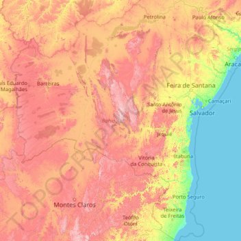
Name: Bahia topographic map, elevation, terrain.
Location: Bahia, Northeast Region, Brazil (-18.39345 -46.57728 -8.53229 -37.17715)
Average elevation: 475 m
Minimum elevation: 0 m
Maximum elevation: 1,878 m
Make a donation
Other topographic maps
Click on a map to view its topography, its elevation and its terrain.
Brasília
Brazil > Federal District > Região Integrada de Desenvolvimento do Distrito Federal e Entorno
The city sits at an elevation of 1,000 metres (3,300 ft) and more, high on the Brazilian Highlands in the country's center-western region. Paranoá Lake, a large artificial lake, was built to increase the amount of water available and to maintain the region's humidity. It has a marina, and hosts wakeboarders…
Average elevation: 1,084 m