
Toledo Bend Reservoir topographic map
Interactive map
Click on the map to display elevation.
About this map
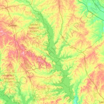
Name: Toledo Bend Reservoir topographic map, elevation, terrain.
Average elevation: 79 m
Minimum elevation: 25 m
Maximum elevation: 184 m
Other topographic maps
Click on a map to view its topography, its elevation and its terrain.
Port O'Connor
USA > Texas > Port O'Connor
Port O'Connor, Calhoun County, Texas, 97982, USA
Average elevation: 3 m
Horseshoe Bay
USA > Texas > Horseshoe Bay
Horseshoe Bay, Llano County, Texas, 78657, USA
Average elevation: 286 m
Startzville
USA > Texas > Startzville
Startzville, Comal County, Texas, 79133, USA
Average elevation: 333 m
Pedernales Falls State Park
Pedernales Falls State Park, Blanco County, Texas, USA
Average elevation: 303 m
Channelview
USA > Texas > Channelview
Channelview, Harris County, Texas, 77530, USA
Average elevation: 7 m
Herbelin Ranch
USA > Texas > Herbelin Ranch
Herbelin Ranch, Comal County, Texas, USA
Average elevation: 336 m
East Columbia
USA > Texas > East Columbia
East Columbia, Brazoria County, Texas, 77486, USA
Average elevation: 10 m
Jesus Maria Colonia
USA > Texas > Jesus Maria Colonia
Jesus Maria Colonia, Hidalgo County, Texas, 78579, USA
Average elevation: 23 m
Prestonwood PID
Prestonwood PID, Dallas, Dallas County, Texas, 75248, USA
Average elevation: 187 m
Mission Bend
USA > Texas > Mission Bend
Mission Bend, Fort Bend County, Texas, 77083, USA
Average elevation: 29 m
Indian Head Mountain
Indian Head Mountain, Brewster County, Texas, USA
Average elevation: 833 m
Webb Chapel Park
Webb Chapel Park, Dallas, Dallas County, Texas, USA
Average elevation: 161 m
Post Oak Ridge
USA > Texas > Lago Vista
Post Oak Ridge, Lago Vista, Travis County, Texas, 78645, USA
Average elevation: 314 m
Amistad Reservoir
USA > Texas > Devils Shores
Amistad Reservoir, Canyon Drive, Devils Shores, Val Verde County, Texas, USA
Average elevation: 440 m
Denny Mountain
Denny Mountain, Nacogdoches County, Texas, 75760, USA
Average elevation: 137 m
Clear Lake City
USA > Texas > Clear Lake City
Clear Lake City, Harris County, Texas, 77058, USA
Average elevation: 8 m