
Church Crookham topographic map
Interactive map
Click on the map to display elevation.
About this map
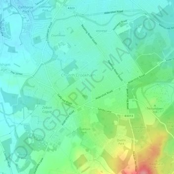
Name: Church Crookham topographic map, elevation, terrain.
Average elevation: 92 m
Minimum elevation: 66 m
Maximum elevation: 166 m
The parent sprawling parish of Crondall (in Crondall Hundred) was mostly rural at this time, with the 1831 edition of Samuel Lewis's Topographical Dictionary of England, which used the census returns to assess that Crookham had 623 inhabitants and not even mentioning the (at the time) much smaller Fleet. Other than Crondall tithing, this parish in 1800 consisted of four other tithings, Crookham (otherwise Church Crookham), Ewshot, Swanthorpe, and portions of Dippenhall (partly in Surrey, in Farnham Hundred). The soil is sandy here and in Ewshot, but is chalky in Swanthorpe and has some clay in other tithings.
Other topographic maps
Click on a map to view its topography, its elevation and its terrain.
Brookly Stream
United Kingdom > England > Hampshire > Hart > Fleet
Brookly Stream, Fleet, Hart, Hampshire, South East England, England, GU51 3RF, United Kingdom
Average elevation: 78 m