
Thank you for supporting this site ❤️
Make a donation
Make a donation
Kagera topographic map
Click on the map to display elevation.
Thank you for supporting this site ❤️
Make a donation
Make a donation
About this map
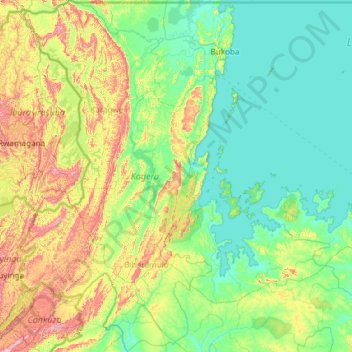
Name: Kagera topographic map, elevation, terrain.
Location: Kagera, Lake Zone, Tanzania (-3.36267 30.40590 -0.98548 32.61871)
Average elevation: 1,284 m
Minimum elevation: 1,130 m
Maximum elevation: 2,034 m
Thank you for supporting this site ❤️
Make a donation
Make a donation
Other topographic maps
Click on a map to view its topography, its elevation and its terrain.
Dodoma
Tanzania > Dodoma Region > Dodoma
The official capital since 1996, Dodoma was envisaged as the first non-monumental capital city as opposed to the monumentality and hierarchy of other planned capital cities such as Abuja, Brasília and Washington, D.C. It rejected geometrical forms such as grid iron and radial plans as inappropriate as the…
Average elevation: 1,145 m
Thank you for supporting this site ❤️
Make a donation
Make a donation