
Marquina-Jeméin topographic map
Interactive map
Click on the map to display elevation.
About this map
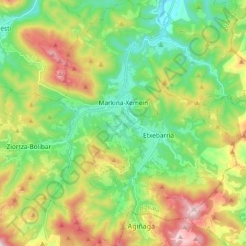
Name: Marquina-Jeméin topographic map, elevation, terrain.
Location: Marquina-Jeméin, Vizcaya, País Vasco, 48270, España (43.21195 -2.53519 43.30729 -2.41787)
Average elevation: 290 m
Minimum elevation: 18 m
Maximum elevation: 773 m
Other topographic maps
Click on a map to view its topography, its elevation and its terrain.
Urko
España > País Vasco > Marquina-Jeméin
Urko, Marquina-Jeméin, Vizcaya, País Vasco, 48270, España
Average elevation: 326 m