
Saint Helena topographic map
Interactive map
Click on the map to display elevation.
About this map
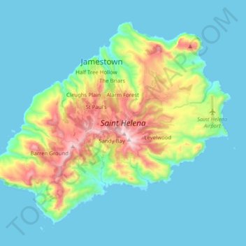
Name: Saint Helena topographic map, elevation, terrain.
Location: Saint Helena, Saint Helena, Ascension and Tristan da Cunha (-16.02745 -5.78996 -15.90386 -5.63423)
Average elevation: 162 m
Minimum elevation: -1 m
Maximum elevation: 797 m
Other topographic maps
Click on a map to view its topography, its elevation and its terrain.
Saint Helena
Saint Helena, Ascension and Tristan da Cunha > Saint Helena > Sandy Bay
Average elevation: 9 m