
Thank you for supporting this site ❤️
Make a donation
Make a donation
Worcester County topographic map
Click on the map to display elevation.
Thank you for supporting this site ❤️
Make a donation
Make a donation
Worcester County
The terrain is mostly level and coastal. The lowest elevation is sea level along the Atlantic Ocean and the highest elevation is 49 ft (15 m) in the northwestern part of the county along State Route 12 just south of the Wicomico County line.
Thank you for supporting this site ❤️
Make a donation
Make a donation
About this map
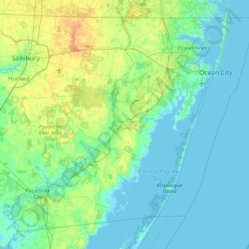
Name: Worcester County topographic map, elevation, terrain.
Location: Worcester County, Maryland, United States (37.99428 -75.66177 38.45204 -74.98520)
Average elevation: 6 m
Minimum elevation: -3 m
Maximum elevation: 28 m
Thank you for supporting this site ❤️
Make a donation
Make a donation
Other topographic maps
Click on a map to view its topography, its elevation and its terrain.