
Thank you for supporting this site ❤️
Make a donation
Make a donation
Lecco topographic map
Click on the map to display elevation.
Thank you for supporting this site ❤️
Make a donation
Make a donation
About this map
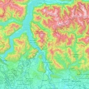
Name: Lecco topographic map, elevation, terrain.
Location: Lecco, Lombardy, Italy (45.64938 9.24373 46.15172 9.54111)
Average elevation: 797 m
Minimum elevation: 153 m
Maximum elevation: 2,550 m
Thank you for supporting this site ❤️
Make a donation
Make a donation
Other topographic maps
Click on a map to view its topography, its elevation and its terrain.