
Purulia - II topographic map
Interactive map
Click on the map to display elevation.
About this map
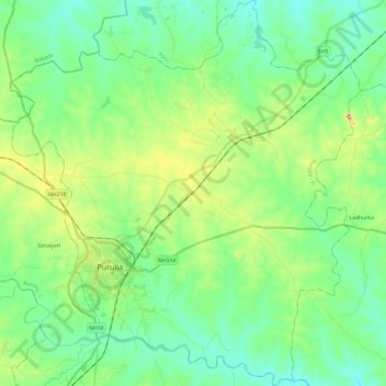
Name: Purulia - II topographic map, elevation, terrain.
Location: Purulia - II, Puruliya, West Bengal, India (23.26134 86.30520 23.48135 86.52287)
Average elevation: 230 m
Minimum elevation: 184 m
Maximum elevation: 354 m
Other topographic maps
Click on a map to view its topography, its elevation and its terrain.
Chittaranjan
India > West Bengal > Chittaranjan
Chittaranjan is located at 23°52′N 86°52′E / 23.87°N 86.87°E / 23.87; 86.87. It has an average elevation of 155 metres (508 feet).
Average elevation: 156 m
Darjeeling
India > West Bengal > Darjeeling
Darjeeling (Bengali: , Nepali: ) is a city and a municipality in the Indian state of West Bengal. It is located in the Lesser Himalayas at an elevation of 2,000 metres (6,700 ft). It is noted for its tea industry, its views of Kangchenjunga, the world's third-highest mountain, and the Darjeeling Himalayan…
Average elevation: 1,331 m
Kalimpong
India > West Bengal > Kalimpong
Kalimpong is a city and a municipality in the Indian state of West Bengal. It is located at an average elevation of 1,250 metres (4,101 ft). The city is the headquarters of the Kalimpong district. Kalimpong district region comes under Gorkhaland Territorial Administration which is an autonomous governing body…
Average elevation: 838 m