
Jambi topographic map
Interactive map
Click on the map to display elevation.
About this map
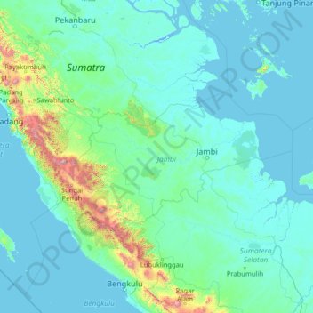
Name: Jambi topographic map, elevation, terrain.
Location: Jambi, Indonesien (-4.17157 100.21970 0.94843 105.33970)
Average elevation: 143 m
Minimum elevation: -3 m
Maximum elevation: 3,293 m
Other topographic maps
Click on a map to view its topography, its elevation and its terrain.
Desa Suka Maju
Indonesien > Jambi > Tebo
Desa Suka Maju, Tebo, Jambi, Indonesien
Average elevation: 82 m
Petaling Jaya
Indonesien > Jambi > Petaling Jaya
Petaling Jaya, Kecamatan Renah Mendaluh, Jambi, Indonesien
Average elevation: 10 m