
Thank you for supporting this site ❤️
Make a donation
Make a donation
Pila topographic map
Click on the map to display elevation.
Thank you for supporting this site ❤️
Make a donation
Make a donation
About this map
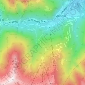
Name: Pila topographic map, elevation, terrain.
Location: Pila, Vercelli, Piedmont, Italy (45.73783 8.05005 45.78068 8.08737)
Average elevation: 1,133 m
Minimum elevation: 630 m
Maximum elevation: 1,892 m
Thank you for supporting this site ❤️
Make a donation
Make a donation
Other topographic maps
Click on a map to view its topography, its elevation and its terrain.
Thank you for supporting this site ❤️
Make a donation
Make a donation
Thank you for supporting this site ❤️
Make a donation
Make a donation