
Ginnheim topographic map
Interactive map
Click on the map to display elevation.
About this map
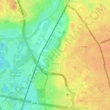
Name: Ginnheim topographic map, elevation, terrain.
Location: Ginnheim, Mitte-Nord, Frankfurt, Hesse, 60431, Germany (50.13617 8.63188 50.15408 8.66277)
Average elevation: 114 m
Minimum elevation: 94 m
Maximum elevation: 130 m
Other topographic maps
Click on a map to view its topography, its elevation and its terrain.
Bergen-Enkheim
Bergen-Enkheim, Frankfurt, Hesse, 60388, Germany
Average elevation: 142 m
Eschersheim
Eschersheim, Frankfurt, Regierungsbezirk Darmstadt, Hesse, 60433, Germany
Average elevation: 117 m