
Lotissement Bellevue topographic map
Interactive map
Click on the map to display elevation.
About this map
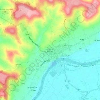
Name: Lotissement Bellevue topographic map, elevation, terrain.
Average elevation: 81 m
Minimum elevation: 22 m
Maximum elevation: 182 m
Other topographic maps
Click on a map to view its topography, its elevation and its terrain.
Sauvage
France > Nouvelle-Aquitaine > Lot-et-Garonne > Clairac > Sauvage
Sauvage, Clairac, Marmande, Lot-et-Garonne, Nouvelle-Aquitaine, France métropolitaine, 47320, France
Average elevation: 74 m
La Pause Nord
France > Nouvelle-Aquitaine > Lot-et-Garonne > Clairac > La Pause Nord
La Pause Nord, Clairac, Marmande, Lot-et-Garonne, Nouvelle-Aquitaine, France métropolitaine, 47320, France
Average elevation: 73 m