
Mountain Base topographic map
Interactive map
Click on the map to display elevation.
About this map
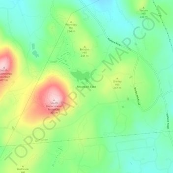
Name: Mountain Base topographic map, elevation, terrain.
Average elevation: 207 m
Minimum elevation: 101 m
Maximum elevation: 402 m
Other topographic maps
Click on a map to view its topography, its elevation and its terrain.
Pinardville
United States > New Hampshire > Hillsborough County > Goffstown
Pinardville, Goffstown, Hillsborough County, New Hampshire, 03102, United States
Average elevation: 86 m
Grasmere
United States > New Hampshire > Hillsborough County > Goffstown
Grasmere, Goffstown, Hillsborough County, New Hampshire, 03045, United States
Average elevation: 115 m