
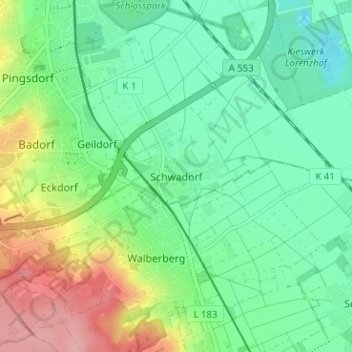
Schwadorf topographic map
Interactive map
Click on the map to display elevation.
About this map
Name: Schwadorf topographic map, elevation, terrain.
Average elevation: 82 m
Minimum elevation: 41 m
Maximum elevation: 168 m
Other topographic maps
Click on a map to view its topography, its elevation and its terrain.
Bleibtreusee
Deutschland > Nordrhein-Westfalen > Rhein-Erft-Kreis > Brühl
Bleibtreusee, Kierberg, Brühl, Rhein-Erft-Kreis, Nordrhein-Westfalen, 50321, Deutschland
Average elevation: 106 m
Heide
Deutschland > Nordrhein-Westfalen > Rhein-Erft-Kreis > Brühl
Heide, Brühl, Rhein-Erft-Kreis, Nordrhein-Westfalen, Deutschland
Average elevation: 105 m
Eckdorf
Deutschland > Nordrhein-Westfalen > Rhein-Erft-Kreis > Brühl
Eckdorf, Brühl, Rhein-Erft-Kreis, Nordrhein-Westfalen, 50321, Deutschland
Average elevation: 106 m
Geildorf
Deutschland > Nordrhein-Westfalen > Rhein-Erft-Kreis > Brühl > Geildorf
Geildorf, Brühl, Rhein-Erft-Kreis, Nordrhein-Westfalen, 50321, Deutschland
Average elevation: 92 m