
Kouba topographic map
Interactive map
Click on the map to display elevation.
About this map
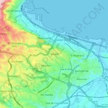
Name: Kouba topographic map, elevation, terrain.
Location: Kouba, Daïra Hussein Dey, Alger, 16040, Algérie (36.69244 3.04697 36.77244 3.12697)
Average elevation: 54 m
Minimum elevation: -3 m
Maximum elevation: 250 m
Other topographic maps
Click on a map to view its topography, its elevation and its terrain.
Babe el Rahba
Algérie > Alger > Daïra Hussein Dey > Kouba
Babe el Rahba, Kouba, Daïra Hussein Dey, Alger, 16005, Algérie
Average elevation: 61 m