
Ajman Emirate topographic map
Interactive map
Click on the map to display elevation.
About this map
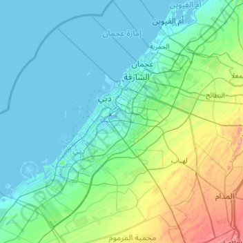
Name: Ajman Emirate topographic map, elevation, terrain.
Location: Ajman Emirate, United Arab Emirates (24.74329 55.23507 25.62301 56.11414)
Average elevation: 53 m
Minimum elevation: -12 m
Maximum elevation: 399 m
Other topographic maps
Click on a map to view its topography, its elevation and its terrain.
Dubai
Dubai lies directly within the Arabian Desert. However, the topography of Dubai is significantly different from that of the southern portion of the UAE in that much of Dubai's landscape is highlighted by sandy desert patterns, while gravel deserts dominate much of the southern region of the country. The sand…
Average elevation: 7 m
Al Ain
United Arab Emirates > Abu Dhabi Emirate > Al Ain > Al Mutaredh
Al Ain is located approximately 160 kilometres (99 mi) east of the capital Abu Dhabi, and about 120 kilometres (75 mi) south of Dubai. The eastern region covers an area of approximately 13,100 km2 (5,100 sq mi). Oman lies to the east, Dubai and Sharjah to the north, Abu Dhabi to the west and the Empty Quarter…
Average elevation: 294 m
Sha'biyyat Al Hiyar
United Arab Emirates > Abu Dhabi Emirate > Al Ain > Al Hiyar
Average elevation: 303 m
Al Ain
United Arab Emirates > Abu Dhabi Emirate > Al Ain
The city is located approximately 160 kilometres (99 mi) east of the capital Abu Dhabi, and about 120 kilometres (75 mi) south of Dubai. The eastern region covers an area of approximately 13,100 km2 (5,100 sq mi). Oman lies to the east, Dubai and Sharjah to the north, Abu Dhabi to the west and the Empty…
Average elevation: 294 m
Wadi Kub
United Arab Emirates > Ras al-Khaimah > Kub
In its upper course, the wadi is formed by two arms of similar length and flow, which originate at approximately an altitude of 542 m (1,778 ft); they border Al Jaroof to the east and west, respectively; and converge to the south of this town, defining the main channel, which initially follows the direction…
Average elevation: 324 m
Hatta
Due to Hatta's higher altitude, its climate is much cooler than central Dubai. Hatta has an arid landscape and temperature, reaching 55 degrees Celsius in the summer; however, it is less humid than Dubai and far colder in the winter.
Average elevation: 371 m
Shi'bat Al Wutah
United Arab Emirates > Abu Dhabi Emirate > Al Ain > Shi'bat Al Wutah
Average elevation: 255 m
Sanaiya Industrial
United Arab Emirates > Abu Dhabi Emirate > Al Ain > Industrial Area
Average elevation: 290 m
Zarkoh Island
United Arab Emirates > Abu Dhabi Emirate > Al Dhafrah Region > Zirku Island
Average elevation: 10 m
Hatta
Due to Hatta's higher altitude, its climate is much cooler than central Dubai. Hatta has an arid landscape and temperature, reaching 55 degrees Celsius in the summer; however, it is less humid than Dubai and far colder in the winter.
Average elevation: 371 m