
Make a donation
Carlsbad topographic map
Click on the map to display elevation.
Make a donation
Carlsbad
Carlsbad is located near the center of Eddy County at 32°24′43″N 104°14′11″W / 32.41194°N 104.23639°W / 32.41194; -104.23639 (32.407577, -104.245167) at an elevation of 3,295 feet (1,004 m). Carlsbad is situated in the northern reaches of the Chihuahuan Desert ecoregion, in the lower Pecos River Valley. Via US 285 it is 36 miles (58 km) north to Artesia and 86 miles (138 km) south to Pecos, Texas. US Routes 62 and 180 lead northeast 69 miles (111 km) to Hobbs and southwest 169 miles (272 km) to El Paso.
Make a donation
About this map
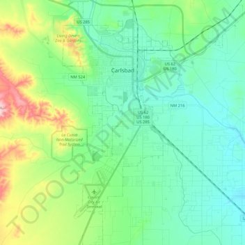
Name: Carlsbad topographic map, elevation, terrain.
Location: Carlsbad, Eddy County, New Mexico, 88220, United States (32.29829 -104.28964 32.47653 -104.13431)
Average elevation: 983 m
Minimum elevation: 925 m
Maximum elevation: 1,159 m
Make a donation
Other topographic maps
Click on a map to view its topography, its elevation and its terrain.