
Thank you for supporting this site ❤️
Make a donation
Make a donation
Lamas topographic map
Click on the map to display elevation.
Thank you for supporting this site ❤️
Make a donation
Make a donation
About this map
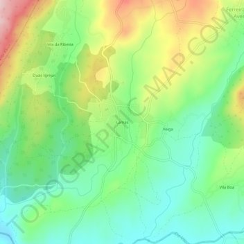
Name: Lamas topographic map, elevation, terrain.
Location: Lamas, Ferreira de Aves, Sátão, Viseu, 3560-020, Portugal (40.77208 -7.70978 40.81208 -7.66978)
Average elevation: 643 m
Minimum elevation: 553 m
Maximum elevation: 797 m
Thank you for supporting this site ❤️
Make a donation
Make a donation
Other topographic maps
Click on a map to view its topography, its elevation and its terrain.