
Plantier Neuf topographic map
Interactive map
Click on the map to display elevation.
About this map
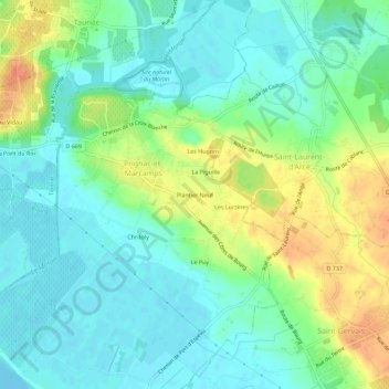
Name: Plantier Neuf topographic map, elevation, terrain.
Average elevation: 16 m
Minimum elevation: -1 m
Maximum elevation: 46 m
Other topographic maps
Click on a map to view its topography, its elevation and its terrain.
Le Puy
France > Nouvelle-Aquitaine > Gironde > Prignac-et-Marcamps
Le Puy, Prignac-et-Marcamps, Blaye, Gironde, Nouvelle-Aquitaine, France métropolitaine, 33710, France
Average elevation: 15 m
Les Neuffons
France > Nouvelle-Aquitaine > Gironde > Prignac-et-Marcamps
Les Neuffons, Prignac-et-Marcamps, Blaye, Gironde, Nouvelle-Aquitaine, France métropolitaine, 33710, France
Average elevation: 16 m