Geolocate

Taunusstein topographic map

Interactive map

Click on the map to display elevation.

About this map

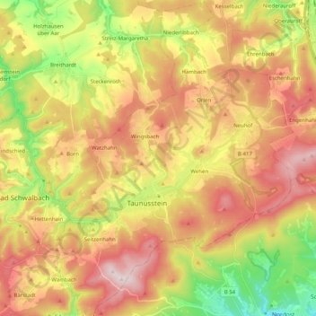
Name: Taunusstein topographic map, elevation, terrain.

Location: Taunusstein, Rheingau-Taunus-Kreis, Hesse, 65232, Germany (50.09365 8.09805 50.22134 8.24305)

Average elevation: 392 m

Minimum elevation: 145 m

Maximum elevation: 621 m

Other topographic maps

Click on a map to view its topography, its elevation and its terrain.

Niedermeilingen

Germany > Hesse > Rheingau-Taunus-Kreis

Niedermeilingen, Heidenrod, Rheingau-Taunus-Kreis, Hesse, Germany

Average elevation: 369 m

Oestrich-Winkel

Germany > Hesse > Rheingau-Taunus-Kreis > Oestrich-Winkel

Oestrich-Winkel, Rheingau-Taunus-Kreis, Hesse, 65375, Germany

Average elevation: 299 m

Idstein

Germany > Hesse > Rheingau-Taunus-Kreis > Idstein

Idstein, Rheingau-Taunus-Kreis, Hesse, 65510, Germany

Average elevation: 354 m