
Hadjadj topographic map
Interactive map
Click on the map to display elevation.
About this map
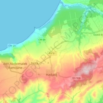
Name: Hadjadj topographic map, elevation, terrain.
Location: Hadjadj, daïra Sidi Lakhdar, Mostaganem, Algérie (36.06199 0.28249 36.18135 0.39542)
Average elevation: 161 m
Minimum elevation: -2 m
Maximum elevation: 436 m
Other topographic maps
Click on a map to view its topography, its elevation and its terrain.
Plage Zina Beach
Algérie > Mostaganem > daïra Sidi Lakhdar > Abdelmalek Ramdane
Plage Zina Beach, Abdelmalek Ramdane, daïra Sidi Lakhdar, Mostaganem, Algérie
Average elevation: 31 m