
Thank you for supporting this site ❤️
Make a donation
Make a donation
Alexander City topographic map
Click on the map to display elevation.
Thank you for supporting this site ❤️
Make a donation
Make a donation
About this map
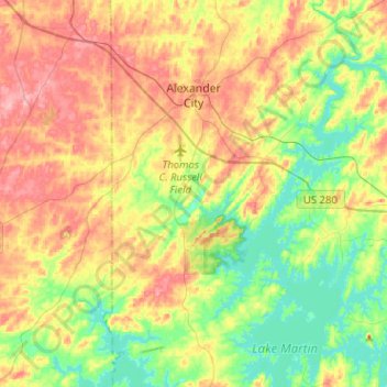
Name: Alexander City topographic map, elevation, terrain.
Average elevation: 188 m
Minimum elevation: 138 m
Maximum elevation: 251 m
Thank you for supporting this site ❤️
Make a donation
Make a donation
Other topographic maps
Click on a map to view its topography, its elevation and its terrain.
Thank you for supporting this site ❤️
Make a donation
Make a donation
Camp Hill
United States > Alabama > Tallapoosa County > Camp Hill > Camp Hill
Average elevation: 203 m