
Thank you for supporting this site ❤️
Make a donation
Make a donation
Acworth topographic map
Click on the map to display elevation.
Thank you for supporting this site ❤️
Make a donation
Make a donation
About this map
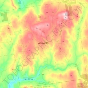
Name: Acworth topographic map, elevation, terrain.
Average elevation: 380 m
Minimum elevation: 172 m
Maximum elevation: 590 m
Thank you for supporting this site ❤️
Make a donation
Make a donation
Other topographic maps
Click on a map to view its topography, its elevation and its terrain.
Thank you for supporting this site ❤️
Make a donation
Make a donation
Mill Hollow
United States > New Hampshire > Sullivan County > Plainfield > Mill Hollow
Average elevation: 313 m