Geolocate

Champaign County topographic map

Click on the map to display elevation.

About this map

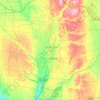
Name: Champaign County topographic map, elevation, terrain.

Location: Champaign County, Ohio, United States (40.01115 -84.03605 40.27346 -83.49479)

Average elevation: 342 m

Minimum elevation: 270 m

Maximum elevation: 456 m

Other topographic maps

Click on a map to view its topography, its elevation and its terrain.

Deerfield

United States > Ohio > Portage County

Average elevation: 321 m

Winton Woods

United States > Ohio

Average elevation: 229 m

Lake Lorelei

United States > Ohio > Brown County > Vera Cruz

Average elevation: 288 m

Beverly Hills

United States > Ohio > Clermont County

Average elevation: 203 m

Haven View

United States > Ohio > Miami County

Average elevation: 299 m

Walnut Creek

United States > Ohio > Holmes County

Average elevation: 327 m

Buena Vista

United States > Ohio > Scioto County

Average elevation: 220 m

Lithopolis

United States > Ohio > Lithopolis > Lithopolis

Average elevation: 277 m

The Highlands

United States > Ohio > Muskingum County

Average elevation: 280 m

Byron

United States > Ohio > Greene County

Average elevation: 280 m

Edinburg

United States > Ohio > Portage County

Average elevation: 351 m

Kilgore

United States > Ohio > Carroll County

Average elevation: 371 m

Homerville

United States > Ohio > Medina County

Average elevation: 330 m

Lake Aquilla

United States > Ohio > Geauga County

Average elevation: 368 m

Fort McKinley

United States > Ohio > Montgomery County > Dayton

Average elevation: 273 m

Wolf Run

United States > Ohio > Jefferson County

Average elevation: 359 m

Valley City Station

United States > Ohio > Medina County

Average elevation: 273 m

Columbia Center

United States > Ohio > Lorain County

Average elevation: 244 m

Rockbridge

United States > Ohio > Hocking County

Average elevation: 262 m

Dundee

United States > Ohio > Tuscarawas County

Average elevation: 328 m

Dunlap

United States > Ohio > Hamilton County

Average elevation: 226 m

Lake Mohawk

United States > Ohio > Carroll County

Average elevation: 333 m

Highpoint

United States > Ohio > Hamilton County

Average elevation: 264 m

Wolfhurst

United States > Ohio > Belmont County

Average elevation: 296 m

Etna

United States > Ohio > Licking County

Etna (formerly Carthage) is an unincorporated community and census-designated place (CDP) in Licking County, Ohio, United States. As of the 2020 census it had a population of 1,209. It lies at an elevation of 1,069 feet (326 m) at the intersection of U.S. Route 40 and State Route 310. It was listed as a…

Average elevation: 321 m

Symmes

United States > Ohio > Hamilton County

Average elevation: 212 m

Sugar Island

United States > Ohio > Ottawa County

Average elevation: 174 m

Villa Nova

United States > Ohio > Auglaize County

Average elevation: 269 m

Slater

United States > Ohio > Auglaize County

Average elevation: 311 m

Santa Fe

United States > Ohio > Auglaize County

Average elevation: 307 m

Glynwood

United States > Ohio > Auglaize County

Average elevation: 267 m

Gutman

United States > Ohio > Auglaize County

Average elevation: 311 m

Kossuth

United States > Ohio > Auglaize County

Average elevation: 256 m

Lock Two

United States > Ohio > Auglaize County

Average elevation: 285 m

Moulton

United States > Ohio > Auglaize County

Average elevation: 271 m

Egypt

United States > Ohio > Auglaize County

Average elevation: 295 m

Fryburg

United States > Ohio > Auglaize County

Average elevation: 302 m

Geyer

United States > Ohio > Auglaize County

Average elevation: 313 m

Bulkhead

United States > Ohio > Auglaize County

Average elevation: 266 m

New Hampshire

United States > Ohio > Auglaize County

Average elevation: 314 m

Utley

United States > Ohio > Athens County

Average elevation: 248 m

Torch

United States > Ohio > Athens County

Average elevation: 226 m

Sharpsburg

United States > Ohio > Athens County

Average elevation: 246 m

Shade

United States > Ohio > Athens County

Average elevation: 258 m

Redtown

United States > Ohio > Athens County

Average elevation: 239 m

Hamley Run

United States > Ohio > Athens County

Average elevation: 234 m

Hartleyville

United States > Ohio > Athens County

Average elevation: 255 m

Hebardville

United States > Ohio > Athens County

Average elevation: 230 m

Lottridge

United States > Ohio > Athens County

Average elevation: 245 m

Luhrig

United States > Ohio > Athens County > Athens

Average elevation: 242 m

Mineral

United States > Ohio > Athens County

Average elevation: 257 m

Modoc

United States > Ohio > Athens County

Average elevation: 263 m

New England

United States > Ohio > Athens County

Average elevation: 248 m

New Floodwood

United States > Ohio > Athens County

Average elevation: 235 m

Pleasanton

United States > Ohio > Athens County > Athens

Average elevation: 267 m

Guysville

United States > Ohio > Athens County

Average elevation: 223 m

Glen Ebon

United States > Ohio > Athens County

Average elevation: 237 m

Garden

United States > Ohio > Athens County

Average elevation: 244 m

Beebe

United States > Ohio > Athens County

Average elevation: 233 m

Bessemer

United States > Ohio > Athens County

Average elevation: 239 m

Big Run

United States > Ohio > Athens County

Average elevation: 237 m

Burr Oak

United States > Ohio > Athens County

Average elevation: 254 m

Canaanville

United States > Ohio > Athens County

Average elevation: 230 m

Carbondale

United States > Ohio > Athens County

Average elevation: 274 m

Doanville

United States > Ohio > Athens County

Average elevation: 236 m

Frost

United States > Ohio > Athens County

Average elevation: 238 m

Beaumont

United States > Ohio > Athens County > Athens

Average elevation: 225 m

Hockingport

United States > Ohio > Athens County

Average elevation: 210 m

Millfield

United States > Ohio > Athens County

Average elevation: 237 m

New Marshfield

United States > Ohio > Athens County

Average elevation: 257 m

Stewart

United States > Ohio > Athens County

Average elevation: 224 m

The Plains

United States > Ohio > Athens County

Average elevation: 234 m

Wick

United States > Ohio > Ashtabula County

Average elevation: 306 m

Griggs Corners

United States > Ohio > Ashtabula County

Average elevation: 271 m

Kelloggsville

United States > Ohio > Ashtabula County

Average elevation: 263 m

Pierpont

United States > Ohio > Ashtabula County

Average elevation: 307 m

West Andover

United States > Ohio > Ashtabula County

Average elevation: 321 m

Eagleville

United States > Ohio > Ashtabula County

Average elevation: 251 m

Footville

United States > Ohio > Ashtabula County

Average elevation: 317 m

Austinburg

United States > Ohio > Ashtabula County

Average elevation: 251 m

Russell

United States > Ohio > Morrow County

Average elevation: 341 m

Williamsdale

United States > Ohio > Butler County

Average elevation: 193 m

Woodsdale

United States > Ohio > Butler County

Average elevation: 204 m

Okeana

United States > Ohio > Butler County

Average elevation: 226 m

Decatur

United States > Ohio > Brown County

Average elevation: 271 m

Lake Waynoka

United States > Ohio > Brown County

Average elevation: 311 m

Warnock

United States > Ohio > Belmont County

Average elevation: 337 m

Captina

United States > Ohio > Belmont County

Average elevation: 289 m

Boston

United States > Ohio > Belmont County

Average elevation: 366 m

Barton

United States > Ohio > Belmont County

Average elevation: 315 m

Badgertown

United States > Ohio > Belmont County

Average elevation: 366 m

Centerville

United States > Ohio > Belmont County

Average elevation: 362 m

Alledonia

United States > Ohio > Belmont County

Average elevation: 320 m