
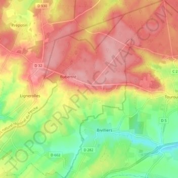
Bubertré topographic map
Interactive map
Click on the map to display elevation.
About this map
Name: Bubertré topographic map, elevation, terrain.
Average elevation: 266 m
Minimum elevation: 198 m
Maximum elevation: 319 m
Other topographic maps
Click on a map to view its topography, its elevation and its terrain.
Belle Perche
France > Normandie > Orne > Tourouvre au Perche
Belle Perche, Randonnai, Tourouvre au Perche, Mortagne-au-Perche, Orne, Normandie, France métropolitaine, 61190, France
Average elevation: 266 m
L'Etre Châtel
France > Normandie > Orne > Tourouvre au Perche
L'Etre Châtel, Autheuil, Tourouvre au Perche, Mortagne-au-Perche, Orne, Normandie, France métropolitaine, 61190, France
Average elevation: 225 m
Lignerolles
France > Normandie > Orne > Tourouvre au Perche
Lignerolles, Tourouvre au Perche, Mortagne-au-Perche, Orne, Normandie, France métropolitaine, 61190, France
Average elevation: 275 m
Autheuil
France > Normandie > Orne > Tourouvre au Perche
Autheuil, Tourouvre au Perche, Mortagne-au-Perche, Orne, Normandie, France métropolitaine, 61190, France
Average elevation: 222 m
La Sablonnière
France > Normandie > Orne > Tourouvre au Perche > La Sablonnière
La Sablonnière, Tourouvre, Tourouvre au Perche, Mortagne-au-Perche, Orne, Normandie, France métropolitaine, 61190, France
Average elevation: 257 m
La Planche
France > Normandie > Orne > Tourouvre au Perche > La Planche
La Planche, Autheuil, Tourouvre au Perche, Mortagne-au-Perche, Orne, Normandie, France métropolitaine, 61190, France
Average elevation: 226 m
Bresolettes
France > Normandie > Orne > Tourouvre au Perche
Bresolettes, Tourouvre au Perche, Mortagne-au-Perche, Orne, Normandie, France métropolitaine, 61190, France
Average elevation: 281 m
Prépotin
France > Normandie > Orne > Tourouvre au Perche
Prépotin, Tourouvre au Perche, Mortagne-au-Perche, Orne, Normandie, France métropolitaine, 61190, France
Average elevation: 277 m