
Thank you for supporting this site ❤️
Make a donation
Make a donation
Winchester topographic map
Click on the map to display elevation.
Thank you for supporting this site ❤️
Make a donation
Make a donation
About this map
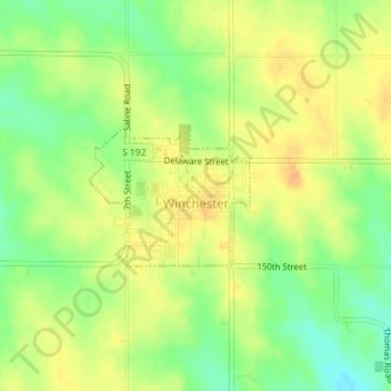
Name: Winchester topographic map, elevation, terrain.
Location: Winchester, Jefferson County, Kansas, United States (39.31789 -95.27642 39.32765 -95.26208)
Average elevation: 352 m
Minimum elevation: 331 m
Maximum elevation: 367 m
Thank you for supporting this site ❤️
Make a donation
Make a donation
Other topographic maps
Click on a map to view its topography, its elevation and its terrain.
Valley Falls
United States > Kansas > Jefferson County > Valley Falls > Valley Falls
Average elevation: 296 m