
Make a donation
Cachoeira do Sul topographic map
Click on the map to display elevation.
Make a donation
Cachoeira do Sul
It is located at a latitude of 30º02'21" S and a longitude of 52º53'38" W, at an approximate elevation of 68 meters above sea level. Its population in 2020 was approximately 81,869 and its area is 3715.5 square kilometers.
Make a donation
About this map
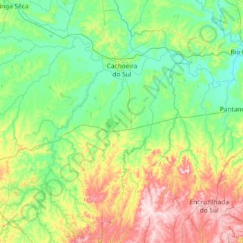
Name: Cachoeira do Sul topographic map, elevation, terrain.
Average elevation: 121 m
Minimum elevation: 4 m
Maximum elevation: 499 m
Make a donation
Other topographic maps
Click on a map to view its topography, its elevation and its terrain.
Porto Alegre
Brazil > Rio Grande do Sul > Metropolitan Region of Porto Alegre > Porto Alegre
Porto Alegre has a long coastline on the Guaíba Lake, and its topography is punctuated by 40 hills. In the lake, a vast body of water, a maze of islands facing the city creates an archipelago where a unique ecosystem gives shelter to abundant wildlife. The city area concentrates 28% of the native flora of Rio…
Average elevation: 27 m
Estrada Carlos Dreyer
Brazil > Rio Grande do Sul > Metropolitan Region of Porto Alegre > Igrejinha
Average elevation: 622 m
Make a donation
Make a donation
Pelotas
Brazil > Rio Grande do Sul > Aglomeração Urbana do Sul > Pelotas
As it is situated on a plain near the ocean, the urban area lies on a low elevation, being, on average, 7 meters (23 ft) above sea level. The interior of the municipality is on a plateau called Serras de Sudeste (Southeastern Mountain Ranges). Consequently, the altitude in Pelotas' rural area reaches 429…
Average elevation: 18 m
Make a donation
Parobé
Brazil > Rio Grande do Sul > Metropolitan Region of Porto Alegre > Parobé > Parobé
Average elevation: 62 m
Make a donation