
Thank you for supporting this site ❤️
Make a donation
Make a donation
Ironia topographic map
Click on the map to display elevation.
Thank you for supporting this site ❤️
Make a donation
Make a donation
About this map
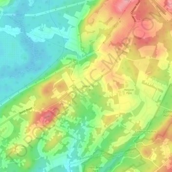
Name: Ironia topographic map, elevation, terrain.
Average elevation: 260 m
Minimum elevation: 206 m
Maximum elevation: 328 m
Thank you for supporting this site ❤️
Make a donation
Make a donation
Other topographic maps
Click on a map to view its topography, its elevation and its terrain.
Lake Cherokee
United States > New Jersey > Morris County > Randolph Township > Calais Crossroads
Average elevation: 295 m